Rim Fire Now More Than 70% Contained But Still Posing A Danger

rim-fire-tamrack-crane-flat-large

As of last night the Rim Fire is over 70% contained but continues to pose a threat as high winds and extremely dry conditions within the Sierra persist. There remains significant potential for long-range spotting to advance beyond control lines. The fire has been burning actively along the south and east fire perimeters in Yosemite National Park. To date the fire has scorched over 235,000 acres, destroyed 11 homes, 3 businesses and injured 5 people. To date the cost of this fire is over $72 million. The above image is a screenshot of the Arcgis Wildland Fire map showing active burning along The Big Oak Flat Road and the Tioga Road at Crane Flat in Yosemite.

The Stanislaus National Forest has issued an area closure for the entire Groveland Ranger District and for the Mi-Wok Ranger District east of Highway 108.

Highway 120 remains closed due to the fire burning along the roadway.

Cherry Lake Road is closed.

Evergreen Road and Hetch Hetchy are closed.

The Old Yosemite Road is closed.

Highway 120 from Ferretti Road to Buck Meadows remains open for local residents and businesses only.

An evacuation advisory remains in effect for Ponderosa Hills and areas east, along the south side of Highway 108 up to Pinecrest.

Highway 120 at the Yosemite National Park boundary west to Buck Meadows has been evacuated.

The Big Oak Flat Road (the continuation of Highway 120 inside Yosemite) remains closed from Big Oak Flat Entrance Station to Crane Flat.

The area west of the May Lake Road and May Lake Trail continuing to the junction with the Pacific Crest Trail (PCT) at Glen Aulin and then north along the PCT to Bond Pass remains closed.

closed-yosemite-aug-29

The following Fire restrictions are in effect throughout the Yosemite Wilderness: no smoking and no building, maintaining, attending, or using a fire, campfire, or cooking fire (including charcoal fires) within Yosemite Wilderness or at the High Sierra Camps. Portable stoves using gas or pressurized liquid fuel are allowed. Alcohol and “Sierra” stoves may not be used in wilderness under these restrictions.

Campfires and cooking fires may be used in the following designated campgrounds and picnic areas in developed portions of the park only: Upper Pines campground, Lower Pines campground, North Pines campground, Camp 4 campground, Wawona campground, Bridalveil Creek campground, Hodgdon Meadow campground, Crane Flat campground, Tamarack Flat campground, White Wolf campground, Yosemite Creek campground, Porcupine Flat campground, Tuolumne Meadows campground, Lembert Dome picnic area, Tenaya Lake pinic area, Yosemite Creek picnic area, Wawona picnic area, Mariposa Grove picnic area, Glacier Point picnic area, Cascade picnic area, El Capitan picnic area, Cathedral Beach picnic area, Sentinel Beach picnic area, Swinging Bridge picnic area, Church Bowl picnic area, and Lower Yosemite Fall picnic area.

May Lake High Sierra Camp, Glen Aulin High Sierra Camp, and Porcupine Flat Campground are open.

Tuolumne and Merced Groves of Giant Sequoia, Hodgdon Meadow and Crane Flat Campgrounds, and the Big Oak Flat Information station are all closed.

Rim Fire Crews Holding Ground

The Rim Fire is now over 32% contained and is expected to be completely contained by September 20th. To date the fire has burned almost 200,000 acres, destroyed 11 residences/buildings and has been responsible for 4 injuries.

closed-yosemite-aug-29

Highway 120 in both directions into Yosemite is still closed to through traffic.

The area west of the May Lake Road and May Lake Trail continuing to the junction with the Pacific Crest Trail (PCT) at Glen Aulin and then north along the PCT to Bond Pass is closed.

The following Fire restrictions are in effect throughout the Yosemite Wilderness: no smoking and no building, maintaining, attending, or using a fire, campfire, or cooking fire (including charcoal fires) within Yosemite Wilderness or at the High Sierra Camps. Portable stoves using gas or pressurized liquid fuel are allowed. Alcohol and “Sierra” stoves may not be used in wilderness under these restrictions.

Campfires and cooking fires may be used in the following designated campgrounds and picnic areas in developed portions of the park only: Upper Pines campground, Lower Pines campground, North Pines campground, Camp 4 campground, Wawona campground, Bridalveil Creek campground, Hodgdon Meadow campground, Crane Flat campground, Tamarack Flat campground, White Wolf campground, Yosemite Creek campground, Porcupine Flat campground, Tuolumne Meadows campground, Lembert Dome picnic area, Tenaya Lake pinic area, Yosemite Creek picnic area, Wawona picnic area, Mariposa Grove picnic area, Glacier Point picnic area, Cascade picnic area, El Capitan picnic area, Cathedral Beach picnic area, Sentinel Beach picnic area, Swinging Bridge picnic area, Church Bowl picnic area, and Lower Yosemite Fall picnic area.

May Lake High Sierra Camp, Glen Aulin High Sierra Camp, and Porcupine Flat Campground are open.

Tuolumne and Merced Groves of Giant Sequoia, Hodgdon Meadow and Crane Flat Campgrounds, and the Big Oak Flat Information station are all closed.

Burnout operations are expected to continue south of Highway 120 on the southeastern edge of the fire from Pilot Ridge to Big Oak Flat Entrance Station. Continued direct and indirect line construction, accompanied by burnout operations where accessibility and safety allow are scheduled to take place along the northern and eastern edges of the fire. Continued contingency line construction in advance of the communities of Tuolumne City, Twain Harte, and Long Barn will continue as well as mopup and and contingency line construction along the western and southern edges of the fire. Crews will continue constructing and improving contingency lines along Dodge Ridge. A large burnout operation is planned for the eastern edge of the fire in Yosemite National Park when conditions become favorable.

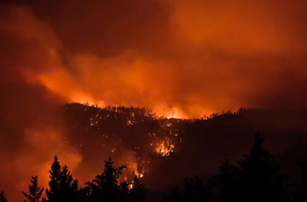
Rim Fire Timelapse Video

Here’s a nice time-lapse of the Rim Fire shot from the Crane Flat helibase. I mean the video is nice not the fire itself. It’s hard to say nice and mention something as destructive as this fire has been.

If you get this in your email and you don’t see the video, click on through to the blog and to watch.

Video courtesy Yosemite National Park.

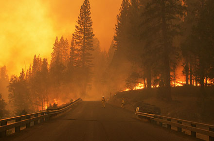
Rim Fire Burning Towards Tioga Road

closed-yosemite-aug-29

The Rim Fire is now 30% contained but has consumed almost 200,000 acres. Four injuries have now been reported since the fire was spotted August 17th.

The fire is continuing to burn towards the Tioga Road in Yosemite National Park. Backfires were not lit yesterday because it was deemed conditions were not conducive to lighting and containing the fire. Firefighters will continue to provide structure defense and improve firelines in the meantime.

Tamarack Flat and Yosemite Creek Campgrounds are closed. White Wolf Campground and White Wolf Lodge will remain closed.

Highway 120 remains closed to Yosemite.

The Tioga Road, from Crane Flat to White Wolf, is closed.

Cherry Lake, Evergreen Road and the Old Yosemite Road are also closed.

The Tuolumne County Sherriff’s Office has lifted the evacuation order for some areas and power is being restored. Highway 120 from Ferretti Road to Buck Meadows remains open only for local residents and business only.

Please keep in mind burned areas continue to pose a danger from falling snags and caution should be used.

May Lake High Sierra Camp, Glen Aulin High Sierra Camp, and Porcupine Flat Campground are open.

The area west of the May Lake Road and May Lake Trail continuing to the junction with the Pacific Crest Trail (PCT) at Glen Aulin and then north along the PCT to Bond Pass is closed.

Tuolumne and Merced Groves of Giant Sequoia, Hodgdon Meadow, Crane Flat Campgrounds, and the Big Oak Flat Information station are closed.

The Crane Flat gas station and store are open.

The Hetch Hetchy Road, including all areas and facilities along the road, is closed.

Tamarack Flat, White Wolf, Yosemite Creek Campgrounds, White Wolf Lodge and Ten Lakes Trailhead parking are closed.

Yosemite Creek Picnic Area is open.

How to Get to Yosemite and Avoid the Fire

Although Highway 120 west and Highway 120 east will both be closed today due to the fire you can still get to Yosemite Valley and Wawona without too much delay.

From San Francisco, Oakland, Sacramento take 99 south past the Highway 120 east in Manteca and continue on to Highway 140 east in Merced. It’s about an hour and a half farther south. Take 140 east through Merced and into Yosemite.

From Los Angeles, San Diego, Fresno, San Bernadino Highway 41 is still open and the most direct route into the park.

If you SHOULD take 120 east because you have lodging in Groveland or Sonora you can take Highway 49 located at the bottom of Priests Grade to Highway 140 in Mariposa and then turn left and take 140 into the park.

If you’re coming up Highway 395 along the Eastern Sierra and you intend to cross via the Tioga Road (Highway 120) you have until noon when the road closes today. Otherwise, it’s the long drive up to Highway 4 or Highway 88. Highway 108 may be closed in some sections.

Keep in mind that if you’re coming to the park you may encounter smokey conditions in some areas. There is no expected opening date for Highway 120 west at this time as the fire continues to burn along the road. All services are still available in Yosemite Valley and Wawona but the Crane Flat area and Highway 120 east are closed due to smoke and fire.

Crews Working to Keep Rim Fire Out of Yosemite

rim-fire-hetch-hetchy-large

To date the fire has consumed almost 185,000 acres and destroyed 111 buildings including the Tuolumne Berkeley Family Camp. Luckily only 2 injuries have been reported and no fatalities. Large sections along Highway 108 and 120 remain under evacuation as the fire continues to threaten over 4500 homes and businesses.

Yesterday, firefighters made progress on spot fires that popped up in the Reynolds Creek drainage and began burning operations south of Duckwall Mountain to Skidmore. Crews were also preparing for additional burning operations on the north side of the Tuolumne River in an effort to keep the fire from pushing north towards Tuolumne City, Long Barn and Pine Crest. Firefighters secured a line from Pilot Ridge west towards the Yosemite boundary along Old Yosemite Highway. Aircraft continued support operations throughout the day.

Today, firefighters are expected to continue with contingency line construction in advance of the communities in the Highway 108 corridor, as well as providing structure protection.

Over 4000 personnel are currently working this fire at an estimated cost of over $33 million.

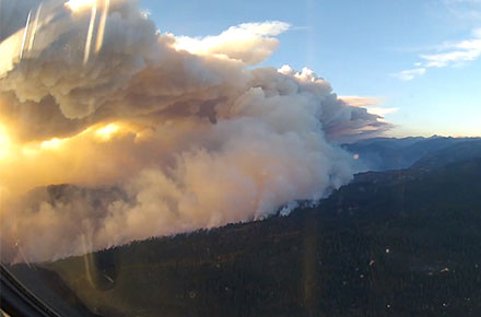
The Rim Fire From Above

If you haven’t been watching these videos on Youtube you’ve missed some very interesting views only a few people see of the Rim Fire. Check out this video from one of the MAFFS C-130J that have been helping to fight the fire in Yosemite and the Stanislaus National Forest by dropping fire retardant. The view is out the front window of the plane and the little gray nub at the bottom is the nose of the plane. The windows are square but appear curved due to lens aberration. If you listen close you’ll hear the pilots commenting on how even they think this is a really impressive fire and they’ve seen a lot of wild fires.

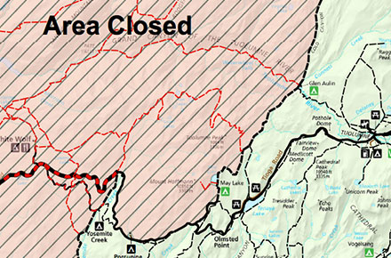
Tioga Road Temporarily Closing

A portion of the Tioga Road, from Crane Flat to White Wolf, will be temporarily closed to all vehicular traffic beginning today, Wednesday, August 28, 2013, at 12:00 noon to allow for fire suppression efforts. Yosemite Valley and the Wawona area will still be accessible via Highway 140 from Merced or Highway 41 from Fresno. Tuolumne Meadows up to Tenaya Lake will only be accessible via Highway 120 from the Tioga Pass entrance. No thru traffic will be allowed.

Rim Fire Update

RIm Fire in Yosemite by Geoff Quinn

As of last night the Rim Fire has burned in excess of 160,000 acres. The fire is now 20% contained but continues to pose a threat as fuels are still extremely dry in the area and high winds are causing spot fires to leap ahead of fire lines. Over 3,700 personnel are working the fire which has cost over $27.2 million to fight.

Fire crews had their hands full with very active fire behavior yesterday. Near Duckwall Ridge, the fire spotted across the line with crews working to control the spot. The fire also crossed the 3N01 road in Reynolds Creek, prompting an expansion of the evacuation advisory in the Highway 108 corridor. Fire crews also were working to contain a spot fire in the southeast portion of the fire as it crossed to the south of Highway 120 at Ackerson Flat. Firefighters were successful in completing dozer line below Pilot Ridge, effectively slowing the fires spread in this location. Tonight crews will continue to work the three spot fires, as well as continue construction on contingency lines and provide structure protection throughout the fire.

Forest Closures

The Stanislaus National Forest has issued an area closure for the entire Groveland Ranger District and for the Mi-Wok Ranger District east of Highway 108. Additional details are available from the Groveland Ranger District, 209-962-7825
Road Closures

Highway 120 remains closed to all inbound and outbound Yosemite National Park traffic to Crane Flat Campground. Highway 120 east/Tioga Road remains open. Also closed are Graham Ranch Road, Smith Station at Highway 120, Cherry Lake at Highway 120, and Evergreen Road. Highway 120 from Ferretti Road to Buck Meadows remains open only for local residents and business only.

Evacuations

The evacuation advisory from Tuolumne City and the area east of Highway 108 has been expanded to Pinecrest Lake. Highway 120 at the Yosemite National Park boundary west to Buck Meadows has been evacuated.

A Mandatory Evacuation has been issued for residences north of Old Yosemite Road (Forest Road 2S01), and an Evacuation Warning has been issued for all residences north of Bull Creek Road (Forest Road 2S02), Bondurant Mine Road, Texas Hill Road, and Wampum Hill.

Photo by Geoff Quinn via Flickr.

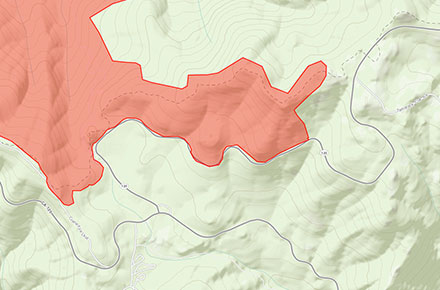
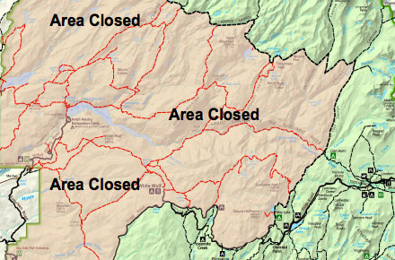
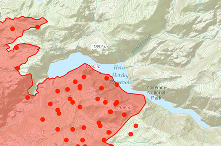
Rim Fire Closures in Yosemite

rim-fire-closures-yosemite

The Rim Fire has made it’s way well into Yosemite National Park and is burning in the north west side of the park and the areas adjacent to Hetch Hetchy. Currently a number of closures are in place for public safety and to allow fire crews to actively fight the fire and prepare defenses around key environmental areas and structures.

Here’s the most recent list of closures from the National Park Service:

The Big Oak Flat Road and Highway 120 west of Yosemite are closed between J132 near Buck Meadows (outside the park) to Crane Flat Campground (inside the park). If you are trying to get to Yosemite from the west, it’s advised you use Highway 140 from Merced. If you find yourself almost in Groveland you can take Highway 49 to Highway 140 in Mariposa (it’s a long VERY curvy, VERY narrow mountain road). You may also enter Yosemite via Highway 41 from the south and 120 from the east (Tioga Pass).

Hetch Hetchy Road and Evergreen Road are closed.

White Wolf is closed, including the lodge, campground, road, and trails originating from White Wolf. This area is closed due to smoky conditions.

Crane Flat, Hodgdon Meadow Campground and Hetch Hetchy Backpackers’ Campground are closed.

Merced and Tuolumne Groves of Giant Sequoias are closed so firefighters can work on preventive fire suppression efforts. The groves are not currently in imminent danger.

Wilderness trail closures: The area west of the May Lake Road and May Lake Trail continuing to the junction with the Pacific Crest Trail (PCT) at Glen Aulin and then north along the PCT to Bond Pass is closed. The park’s boundary serves as the closure’s northern and western edge extending south to Crane Flat Campground. The closure boundary continues east along the Tioga Road (Highway 120 through the park) to the May Lake Road. The Tioga Road and the trails serving as the eastern boundary of the closed area (including the PCT) remain open. May Lake High Sierra Camp, Glen Aulin High Sierra Camp, and Porcupine Flat Campground are open.

Fire restrictions: No smoking and no building, maintaining, or using a fire, campfire or cooking fire (including charcoal fires) within the Yosemite Wilderness and potential wilderness additions. Portable stoves using gas or pressuring liquid fuel are allowed. Alcohol and Sierra stoves are not allowed. Campfires may still be used in designated campsites at designated campgrounds in non-wilderness areas within the park.

All other roads and areas are open. Yosemite Valley, Glacier Point, Wawona, Mariposa Grove, and Tuolumne Meadows areas are all open. Campgrounds in Wawona, Bridalveil Creek, Yosemite Valley, Porcupine Flat, and Tuolumne Meadows are open.