How The Rim Fire was Conquered

Ever since I was a little boy I’ve loved maps and to this day I keep an abundance of them around the house always ready to be pulled out at the drop of a hat. Check out this interesting map of the Rim Fire. It has all the firelines marked on it which makes it REALLY interesting. You can see the things the fire crews focused on, you can see lines that were cut and overrun by the fire and you can see where the fire is still burning.

Click the image to view full size.

rim-fire-final-burn-large

Rim Fire and Road Closure Update

As of last night the Rim Fire is holding at 80% containment with over 255,000 acres burned. To date the fire has cost an estimated $102 million, destroyed 11 residences, 3 businesses, 97 outbuildings and continues to threaten over 1200 structures.

Evergreen Road has opened to Evergreen Lodge. The road is still closed beyond the Lodge.

Extremely hot and dry conditions are continuing to cause difficulties for firefighters. The fire has been very active torching and spotting unburnt fuels inside the control lines. The fire is active in the Clavey River Reynolds Creek and Jawbone Creek drainages as well as to the west of Harden Lake Harden Road and Tioga Road. Moderate fire spread to the northeast into Yosemite Wilderness areas north of Hetch Hetchy reservoir is expected.

The Big Oak Flat Road is open into Yosemite Valley.

Highway 120 is open to Crane Flat from the West and to 1 1/2 miles east of White Wolf.

Businesses along the road are open and providing services (gasoline food and lodging) for travelers.

Cherry Lake Road is closed at Highway 120.

rim-fire-september-11-2013-closures

The Old Yosemite Road and Hardin Flat Road are also closed.

The Hetch Hetchy Road, including all areas and facilities along the road, is closed.

The area west of the Lukens Lake trail north along the Harden Lake bypass trail to Pate Valley, and north from Pate Valley to the junction with the Pacific Crest Trail (PCT) then continuing north along the PCT to Bond Pass is closed. The park’s boundary serves as the closure’s northern and western edge south to Crane Flat. The closure continues east ½ mile south along the Tioga Road to the gate 1 ½ miles east of White Wolf.

Rim Fire Burning Towards Tioga Road

closed-yosemite-aug-29

The Rim Fire is now 30% contained but has consumed almost 200,000 acres. Four injuries have now been reported since the fire was spotted August 17th.

The fire is continuing to burn towards the Tioga Road in Yosemite National Park. Backfires were not lit yesterday because it was deemed conditions were not conducive to lighting and containing the fire. Firefighters will continue to provide structure defense and improve firelines in the meantime.

Tamarack Flat and Yosemite Creek Campgrounds are closed. White Wolf Campground and White Wolf Lodge will remain closed.

Highway 120 remains closed to Yosemite.

The Tioga Road, from Crane Flat to White Wolf, is closed.

Cherry Lake, Evergreen Road and the Old Yosemite Road are also closed.

The Tuolumne County Sherriff’s Office has lifted the evacuation order for some areas and power is being restored. Highway 120 from Ferretti Road to Buck Meadows remains open only for local residents and business only.

Please keep in mind burned areas continue to pose a danger from falling snags and caution should be used.

May Lake High Sierra Camp, Glen Aulin High Sierra Camp, and Porcupine Flat Campground are open.

The area west of the May Lake Road and May Lake Trail continuing to the junction with the Pacific Crest Trail (PCT) at Glen Aulin and then north along the PCT to Bond Pass is closed.

Tuolumne and Merced Groves of Giant Sequoia, Hodgdon Meadow, Crane Flat Campgrounds, and the Big Oak Flat Information station are closed.

The Crane Flat gas station and store are open.

The Hetch Hetchy Road, including all areas and facilities along the road, is closed.

Tamarack Flat, White Wolf, Yosemite Creek Campgrounds, White Wolf Lodge and Ten Lakes Trailhead parking are closed.

Yosemite Creek Picnic Area is open.

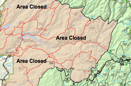
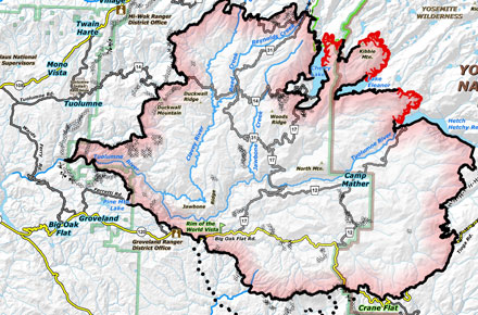
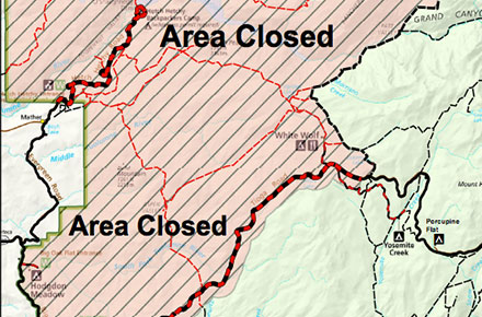
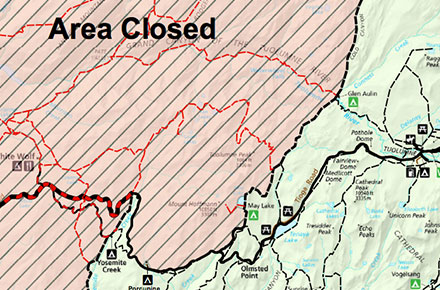
Rim Fire Closures in Yosemite

rim-fire-closures-yosemite

The Rim Fire has made it’s way well into Yosemite National Park and is burning in the north west side of the park and the areas adjacent to Hetch Hetchy. Currently a number of closures are in place for public safety and to allow fire crews to actively fight the fire and prepare defenses around key environmental areas and structures.

Here’s the most recent list of closures from the National Park Service:

The Big Oak Flat Road and Highway 120 west of Yosemite are closed between J132 near Buck Meadows (outside the park) to Crane Flat Campground (inside the park). If you are trying to get to Yosemite from the west, it’s advised you use Highway 140 from Merced. If you find yourself almost in Groveland you can take Highway 49 to Highway 140 in Mariposa (it’s a long VERY curvy, VERY narrow mountain road). You may also enter Yosemite via Highway 41 from the south and 120 from the east (Tioga Pass).

Hetch Hetchy Road and Evergreen Road are closed.

White Wolf is closed, including the lodge, campground, road, and trails originating from White Wolf. This area is closed due to smoky conditions.

Crane Flat, Hodgdon Meadow Campground and Hetch Hetchy Backpackers’ Campground are closed.

Merced and Tuolumne Groves of Giant Sequoias are closed so firefighters can work on preventive fire suppression efforts. The groves are not currently in imminent danger.

Wilderness trail closures: The area west of the May Lake Road and May Lake Trail continuing to the junction with the Pacific Crest Trail (PCT) at Glen Aulin and then north along the PCT to Bond Pass is closed. The park’s boundary serves as the closure’s northern and western edge extending south to Crane Flat Campground. The closure boundary continues east along the Tioga Road (Highway 120 through the park) to the May Lake Road. The Tioga Road and the trails serving as the eastern boundary of the closed area (including the PCT) remain open. May Lake High Sierra Camp, Glen Aulin High Sierra Camp, and Porcupine Flat Campground are open.

Fire restrictions: No smoking and no building, maintaining, or using a fire, campfire or cooking fire (including charcoal fires) within the Yosemite Wilderness and potential wilderness additions. Portable stoves using gas or pressuring liquid fuel are allowed. Alcohol and Sierra stoves are not allowed. Campfires may still be used in designated campsites at designated campgrounds in non-wilderness areas within the park.

All other roads and areas are open. Yosemite Valley, Glacier Point, Wawona, Mariposa Grove, and Tuolumne Meadows areas are all open. Campgrounds in Wawona, Bridalveil Creek, Yosemite Valley, Porcupine Flat, and Tuolumne Meadows are open.

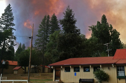
Rim Fire Now Threatening Groveland, Cherry Lake, Lake Eleanor areas

Rim Fire from the air by Al Greening

Al Greening was flying into the Bay Area and, passing by the Rim Fire burning just outside Yosemite, grabbed his camera and took this awe-inspiring shot.

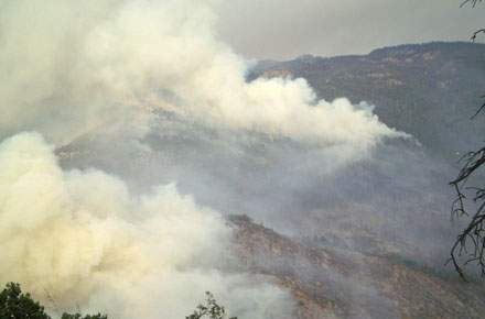
The Rim Fire has burned over 60,000 acres and is continuing to burn unchecked. Last reports have the fire again spreading north, this time toward Cherry Lake and Lake Eleanor. More of our friends in Groveland have been evacuated as the fire moves west toward Pine Mountain Lake.

Here’s last nights report from Inciweb. This morning’s report won’t be up until after daybreak when commanders and air crews can survey the fires overnight growth.

Fire continues its eastward spread along Packerd Canyon Road and Pilot Ridge. Structure defense continues for San Jose Camp, Spinning Wheel and Tawonga Camp as the fire moves up the middle fork of the Tuolumne

The fire continues to spread northwest burning past Butcher Knife Ridge and moving into Grapevine Creek; northeast up the Tuolumne River Drainage from the Gravel Range past Jones Point Lookout; and continue to spread southeast edge along Hwy 120 to the east.

Firing operations have begun on Ferretti Rd. as the fire progress west towards the community of Pine Mountain Lake. Direct suppression methods have been successful.

The availability of fixed wing air craft is pertinent to the success of suppression operations. The use of Maffs C-130s and the V-LAT DC-10 has greatly improved suppression efforts. Use of Military Rotary wing aircraft continues today.

In the next 24 hours the fire is expected to continue up the Tuolumne River canyon, and continue its spread to the north and east.

Due to inaccessible, steep terrain and active fire behavior a combination of direct and indirect attack will be used on this incident. Direct line suppression efforts are impeded by difficult access and steep inaccessible terrain. Active fire behavior today raises safety concerns for crews adjacent to the fire’s edge. Smoke exposure within the deep drainage of the Clavey River will be an issue for fire crews as well.

Highway 120 remains closed to all inbound and outbound Yosemite National Park traffic. Ferretti Road and Highway 120 to Pine Mountain Drive, Smith Station at Highway 120, Cherry Lake at Highway 120, and Evergreen Road.

An evacuation order has been ordered for the area north of Ferretti Road to Elderberry Road. An evacuation advisory has been issued for the community of Pine Mountain Lake. Communities along Ferretti Road from Highway 120 to Pine Mountain Road and Highway 120 at the Yosemite National Park boundary west to Smith station have been evacuated.

We have lots of friends and family in the area and on the fire lines. Our thoughts and prayers are with them today.

Photo by Al Greening via Flickr

Fire Closes Highway 120, North Entrance of Yosemite

The Rim Fire has already burned 800 acres and continues to burn unchecked as it makes it’s way south, prompting the closure of Highway 120 from Groveland to Yosemite and evacuations of park guests, local businesses and homes.

The fire, which was discovered by a spotter plane Saturday, began burning along the south side of the Clavey River Canyon. As winds picked up the fire gained momentum up Jawbone Ridge before jumping the Clavey and Tuolumne rivers and working its way uphill to Highway 120 and the Groveland Ranger Station just east of Ferretti Road.

Areas under evacuation orders included the San Jose Family Camp, Yosemite Riverside Inn, Spinning Wheel Ranch and areas near Buck Meadows, according to the Forest Service.

If you’re headed up that way it’s advised you call and confirm your lodging reservations or make alternate plans. The air is very smokey and hard to breathe. If you have a respiratory condition or are sensitive to bad air you’re being warned to stay away as conditions aren’t likely to improve anytime soon.

An alternate route into Yosemite is available by following Highway 49 to Mariposa and entering through the Highway 140 entrance.

To keep up with current road conditions please visit http://www.dot.ca.gov/cgi-bin/roads.cgi.

Photo courtesy GoldrushCam.com

Aspen Fire Leaving Cloud of Smoke Over California

If you’ve seen the brown air we have right now then well, you’ve seen one of the effect fire can have in California in the summer. Check out the Yosemite Conservancy webcams and you’ll see what I mean.

What’s causing this? Well, right now, Yosemite and most of Central California is being covered by a thick blanket of smoke coming from the Aspen Fire in Fresno county. The fire was started last week by lightning is now and has burnt over 14,000 acres as of Tuesday night costing an estimated $10.6 million. It’s also dumping lots of smoke in the air which may cause problems for sensitive individuals. Unfortunately, except for being indoors, there’s really no place in Central California safe from the smoke from this fire. It’s going all the way to Canada! Check out the map below.

Fun stuff, huh? If you are coming to Yosemite and you are sensitive to smoke, try to stay indoors as much as possible. I know, it might ruin your vacation but try rearranging your schedule a little to minimize the effects of the smoke. Only go out during the evening when smoke is higher in the atmosphere and stay inside in the morning when it settles low into the valleys and canyons. Keep windows and doors closed as much as possible. If you’re even the slightest bit asthmatic carry your rescue inhaler and be ready to use it. Avoid any long, strenuous hikes.

Have fun and be safe!

Fire at Glacier Pt. Gifts

First, my apologies for the long silence. I spilled some water on my keyboard, and I’m having issues with several letters not functioning at all, or wonkily. I’m relying on the keyboard viewer to type this.  

Now to the news; There was a fire at Glacier Pt. Gift store this morning. No one was seriously injured, but one employee was treated for smoke inhalation and released.  The store will be open for business once the sparkler system has been reset, probably by Saturday, July 21st. 

Thank you to the NPS rangers and fire crew for their timely help.  

First prescribed fire of 2012 to be ignited tomorrow conditions permitting

Yosemite National Park Fire Managers are planning a prescribed fire in the north western portion of the park near the Big Oak Flat Entrance Station on Highway 120 (Big Oak Flat Road) on Tuesday, June 19, 2012. The ignition of the fire is dependent on weather conditions. The total prescribed burn area will include 220 acres and be split into two units. The prescribed area is at the optimal fuel moisture level to successfully complete the project. This will be the first prescribed burn of the 2012 fire season.

The two units have minimal fire history between 1930 and 1990, although natural fire history is evident in the area by fire scars on several mature trees. Since 1990, a hazardous fuel reduction program has been implemented to protect private and public structures around the Hodgdon Wildland Urban Interface (WUI). The most recent projects were last summer with over 500 acres being treated. A mixture of fuel reduction techniques have been used including mechanical thinning, pile burning and prescribed burning. These WUI treatments have created defensible space for the Hodgdon residential area. This project will not only extend the defensible space, but also facilitate the reintroduction of fire into the ecosystem and restore the forest area. Combined with other burns near Crane Flat, and Rockefeller Grove areas, and with the fuel reduction projects conducted by the Stanislaus National Forest along Evergreen Road, this project will further reduce the likelihood of catastrophic fire originating at lower elevations, either inside or outside of the park affecting communities in mixed confer pine forest.

It is estimated that the burn will take approximately three days to complete. Smoke from the burn may be visible throughout the park, but may be more evident in the northern portion of the park. Smoke, affecting health, is always a consideration in the decision to schedule prescribed fires. A smoke management plan has been submitted to the Tuolumne County Air Pollution Control District, and a burn permit has been issued. Smoke monitors will be placed in and around the area of the prescribed fire to monitor Yosemite’s air quality. (via NPS)

Ironically, CalFire has suspended debris-burning permits in the Sierra this weekend citing that wildfire danger is too high.

Prescribed Fire May Make Smokey Conditions in Wawona Area

Since I was diagnosed with severe asthma last year I’m very cautious about the air I breathe. That’s why I pay attention to prescribed burn notices in and around Yosemite to make sure I don’t have any issues. That means if you’ve got asthma like me, you’ll probably want to stay away from the Wawona area while this prescribed burn takes place this week as it may make the air a little less than favorable.

Yosemite National Park Fire Managers are planning a prescribed fire in the northwest Wawona area in the southern portion of the park on Wednesday, May 16, 2012. The ignition of the burn is dependent on weather conditions. Favorable weather is expected throughout the week, which will allow for optimal smoke dispersion. The total prescribed fire area will include 846 acres and is estimated to take several days to one week to complete. This will be the first prescribed fire of the 2012 fire season.

The prescribed fire will take place in the vicinity of the 2007 lighting caused fire, known as the Jack Fire. The fire is designed to reduce hazardous fuels in the Wawona Wildland Urban Interface area. Burning this segment will form a barrier to the community of Wawona from the spread of unwanted wildfire approaching from Turner Ridge to the north and from the South Fork Merced River drainage to the northwest. This project ties together multiple and historical research, natural and prescribed fires, and mechanical thinning.

Another objective for this project is to conduct ecosystem restoration by applying fire to landscape adapted to thrive in fire conditions. Fire is a natural process that plays an integral role in shaping the Yosemite landscape. Densities of shade tolerant tree species, such as white fir and incense cedar, and forest litter and duff have accumulated to unnatural levels in the absence of fire. Through the application of fire, a more natural vegetation composition on the forest floor can flourish.

Smoke from the fire may be visible throughout the park, but may be more evident in the Wawona area and the southern portion of the park. Additionally, fire equipment and fire crews will be present in the area of the fire and along roadways. Visitors and park employees are urged to drive slowly and with caution through the burn area.

(via NPS)