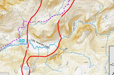
The fire is burning in the wilderness area of Little Yosemite Valley and is now approximately 2,582 acres (click map to see full size). All trails in the area are closed. Approximately 100 hikers and backpackers were evacuated from the fire area in LYV. The High Sierra Camps were seasonally closed today.
Eighty-five hikers and climbers were also evacuated from the summit of Half Dome by helicopters from the California Highway Patrol, Department of Agriculture Forest Service, Sequoia Kings Canyon National Park, and CAL Fire.
The South Central Sierra Interagency Management Team will begin management of the fire at 6 PM, September 8, 2014.
Resources:
- 4 Type 1(heavy helicopters),
- 3 Type 2 (medium helicopters)
- 1 Air Attack
- 3 Air Tankers
- Over 100 firefighters are assigned, including Yosemite fire crews and 6 Hot Shot crews
Closed Trails:
- Echo Creek Drainage to LYV
- Sunrise Creek Drainage to LYV (John Muir Trail)
- Merced River Corridor to Merced Lake Ranger Station
- Nevada falls east through LYV along the Merced River corridor.
- Sunrise trail to Clouds Rest from Tenaya Lake


Comments
5 responses to “Meadow Fire Update”
The fire is burning in the wilderness area of Little Yosemite Valley and is now approximately 2,582 acres. All… http://t.co/vkrhEXBjoS
Meadow Fire Update: Here’s the latest on the fast moving fire burning in Little Yosemite Valley. Related posts: *… http://t.co/2LkeDR4KT6
RT @THEYosemiteBlog: Meadow Fire Update http://t.co/k69gqcqAqn
I’ve had a backpack trip planned for the past month from cathedral lakes into the valley, i’m from PA and my flight is this friday. Any suggestions? is anything still open to make a backpacking trip possible????
I’ll be posting a more inclusive map this morning showing the fire area. Everything around and through LYV is closed.These are the current trail closures:
Echo Creek Drainage to Little Yosemite Valley
Sunrise Creek Drainage to Little Yosemite Valley
Merced River Corridor to Merced Lake Ranger Station
Sunrise Trail to Clouds Rest from Tenaya Lake
Best bet is to look at a map and give the National Park Service Wilderness Office a call right away.