It’s important to remember that the Railroad Fire isn’t the only fire that will be affecting your Labor Day weekend trip to Yosemite. The South Fork Fire and Empire Fire both continue to burn between the Glacier Point Road and Wawona causing all trails in the area (see map below) as well as the Glacier Point Road and Bridalveil Creek Campground to remain closed.
Here’s the latest on the two fires.
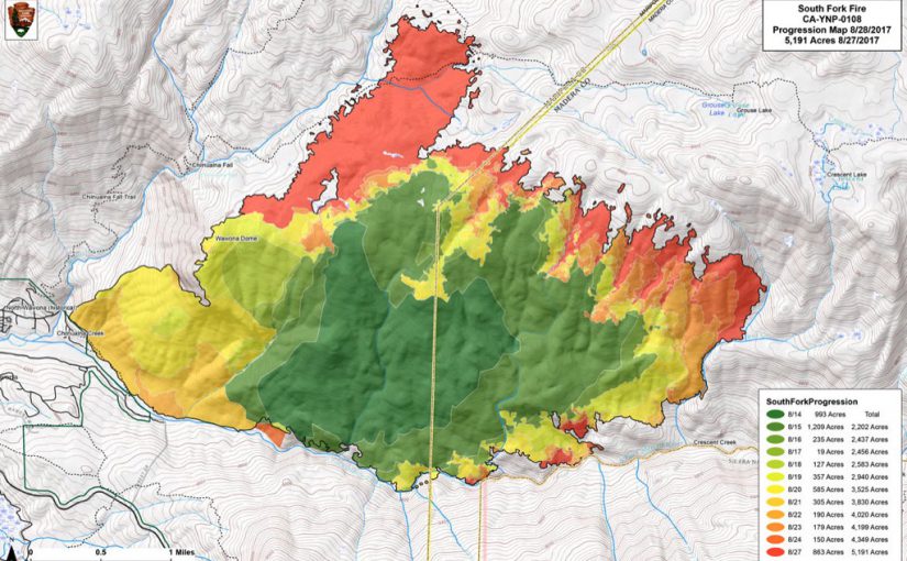
South Fork Fire (Wawona Area)
Estimated Start Date: 8/13/17
Location: N 37°32 ’15” x W 119° 35’54”
Size: 6,100 acres
morning.Crews will continue to patrol and monitor the flanks closest to the community of Wawona and Mariposa Grove. Crews are continuing containment strategies on the north-west edge of the fire and to keep fire south and south-east of Chilnualna Creek. The north and east flank of the fire is continuing to burn in the wilderness, and will be monitored by aircraft due to inaccessible and steep terrain. As fire burns into the high country wilderness it will burn actively through pockets of dense vegetation but will then slow down as it progresses into sparse vegetation and natural granite barriers limiting smoke production. This high country wilderness area has few high values at risk.
Empire Fire (Bridalveil Creek Campground/Glacier Point Road)
Location: N 37° 38.673′ x W 119° 37.096′ at roughly 7300 feet elevation, 1 mile east of Yosemite Ski and Snowboard Area and 3/4 mile south of Glacier Point Road
Size: 4,150 acresYesterday, August 30th, growth of the fire was moderated due to lower temperatures, higher humidities and cloud cover. Light precipitation was received over the fire area this morning. The west and northwest flanks of the fire are contained and showed minimal activity.
Fire crews are implementing a perimeter control strategy for the north, west, and southern flanks of the fire to protect Bridalveil Campground, Yosemite Ski and Snowboard Area, Yosemite West subdivision, Wawona Road (Highway 41), and Glacier Point road. There was a firing operation on the south flank of the fire to tie in containment lines on the Deer Camp trail. Fire management personnel are implementing this strategy on three sides of the fire to also limit further smoke production in heavy fuels. Strategy for the east flank of the fire is to steer fire east deeper into the wilderness where there is sparse vegetation and natural granite barriers, which will slow spread and limit smoke production. This high country wilderness area is very steep and rugged and has few high values at risk.
Glacier Point road is closed to the public due to fire fighter safety to conduct tree felling and vegetation clearance; conditions are being assessed as to when the road can be opened again. Additional crews and engines are on order to support these operations.
Area Closures
- Glacier Point Road
- Bridalveil Creek Campground
Trail Closures
- The Swinging Bridge trail
- Ostrander Lake is closed from Bridalveil and Lost Bear Meadow trailheads
- Chilnualna Falls Trail is closed including access to Chilnulana creek and Grouse, Crescent and Johnson Lakes
- Deer Camp is closed including access from Turner Meadow, Empire Meadow, and Bridalveil Creek

